Thursday, 15 December 2016

Earth's slow surface warping


British researchers are now routinely mapping a great swathe of Earth's surface, looking for the subtle warping that ultimately leads to quakes.
The team is processing satellite images to show how rocks in a belt that stretches from Europe's Alps to China are slowly accumulating strain.
Movements on the scale of just millimetres per year are being sought.
The new maps are being made available to help researchers produce more robust assessments of seismic hazard.
The kind of change they are trying to chart is not noticeable in the everyday human sense, but over time will put faults under such pressure that they eventually rupture - often with catastrophic consequences.
This pair of spacecraft repeatedly and rapidly image the surface of the globe, throwing their data to the ground using a high-speed laser link. And by comparing whole stacks of their pictures in a technique known as interferometry, the COMET group can begin to see the very slow bending and buckling that occurs in the crust as a result of shifting tectonic plates.


http://www.bbc.co.uk/news/science-environment-38323832

Geothermal Borehole in Iceland


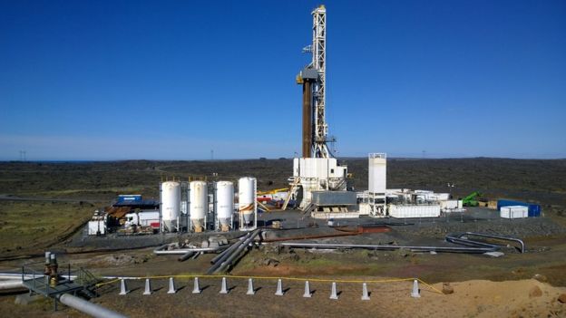
Geologists say they are close to creating the hottest borehole in the world.
They are drilling into the heart of a volcano in the south-west of Iceland.
They have told the BBC that they should reach 5km down, where temperatures are expected to exceed 500C , in the next couple of weeks.
The researchers want to bring steam from the deep well back up to the surface to provide an important source of energy.
The project is located on the Reykjanes peninsula, quite near  the Blue Lagoon, where a volcano last erupted 700 years ago.
A huge rig stands out against the black lava fields; inside a drill has been operating for 24 hours a day since August.
It has now descended nearly 4,500m, and the team expects it to hit its target depth of 5km by the end of the year.

http://www.bbc.co.uk/news/science-environment-38296251

Tuesday, 29 November 2016

Krakatoa eruption, the loudest noise on Earth?


On August 27, 1883, Krakatoa (alternately called Krakatau), an uninhabited volcanic island near Indonesia, erupted spectacularly, expelling huge clouds of gas and ash, generating massive tsunamis, and killing more than 36,000 people. Here are a few things you might not have known about one of the most powerful and devastating eruptions in modern history, which had effects worldwide.

Thanks to Finn for the link below, Watch 4:32-6:13

https://www.youtube.com/watch?v=fWh66eX_5O8

New Zealand Earthquake


The great wall of New Zealand: Incredible aftermath of the 7.8 magnitude earthquake that has created 15ft high natural barriers across the landscape 

Read more: http://www.dailymail.co.uk/news/article-3981546/The-great-wall-New-Zealand-Incredible-aftermath-7-8-magnitude-earthquake-created-15ft-high-natural-barriers-landscape.html#ixzz4RR3xSJon


Thursday, 13 October 2016

Amazing cloud formation


Residents in Somerset were in for a surprise this morning, when they spotted what could easily be mistaken for a UFO in the sky.
The rare atmospheric phenomenon is a strange cloud formation, known as fallstreak, or hole-punch clouds.
These unfamiliar clouds form when temperatures are below freezing, but water droplets in the clouds have yet to freeze due to a lack of ice particles.
When ice particles form quickly, it causes a domino effect as the water droplets connect with the crystals, which get heavier and then start to fall all of a sudden - leaving a large hole in the cloud.
The wispy clouds that form in the center of the hole are the water particles falling.
Passing airplanes are thought to be the reason behind the formation of these clouds, since a drop in pressure caused by their wings or propeller tips cools the air quickly.


Read more: http://www.dailymail.co.uk/sciencetech/article-3831082/Who-punched-sky-Strange-cloud-formation-leaves-hole-looks-like-UFO-Somerset.html#ixzz4MzFzuVRQ
Follow us: @MailOnline on Twitter | DailyMail on Facebook

50 years of Volcanic eruptions & Earthquakes


It is a stunning animation showing exactly how the earth moves.
Researchers at the Smithsonian National Museum of Natural History have unveiled the E3 map - showing eruptions, earthquakes and emissions. The team behind it say the map is akin to watching the pulse of our planet.
The map tracks every recorded volcanic eruption, earthquake and major sulfur dioxide emission since 1960. 

http://video.dailymail.co.uk/video/mol/2016/10/12/5959478329016142820/640x360_MP4_5959478329016142820.mp4


Friday, 30 September 2016

We Need a New Definition for “Magma”


Confusion over the meaning of "magma" can generate popular misperceptions, including a nonexistent molten sea underneath Yellowstone National Park. We propose a different definition:

https://eos.org/opinions/we-need-a-new-definition-for-magma